Search Term Record
Metadata
Name |
Disaster |
Number of Photo records |
57 |
Related Records
-
P-0036.02 - HOCKERSVILLE / BUILDINGS
HOCKERSVILLE BUILDINGS 5 - Fire that destroyed the barn at corner of Hockersville Road, Governor Road and Elm Avenue in 1952 - Note Erb's Store at the far left of photo - Hockersville Road is between Erb' s Store and the barn - later the area was used to build the Masonic Lodge;
Record Type: Photos Search
-
P-0040 - DISASTER / HURRICANE
SNAVELY HOUSE 1 - Cleaning up the Joseph Snavely house on Java Avenue destroyed by the uprooting of a gas line by a falling tree during Hurricane Hazel in 1954. The house blew up when one of the occupants tried to light a match because of the loss of electrical lights. Though the house did not have a gas line to it, the uprooted line allowed gas to seep into the structure. Mrs. Snavely was killed and Joseph was seriously injured, ...
Record Type: Photos Search
-
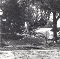
P-0040.01 - DISASTER / HURRICANE
SNAVELY HOUSE 3,4,5,6,7,8,9,10,11,12 - The remains of the Joseph Snavely House after the October 15, 1954 explosion that destroyed the house. During Hurricane Hazel a tree fell and broke a gas line. When a candle was lit inside the house an explosion caused this damage. Gilbert Lugar, a Hershey Vocational School teacher, helped to clean up the debris from the explosion. He found the workings of the Snavely Grandfathers clock i...
Record Type: Photos Search
-
P-0040.02 - DISASTER / HURRICANE
SNAVELY HOUSE 13,14,15,16 - The remains of the Joseph Snavely House after the October 15, 1954 explosion that destroyed the house. During Hurricane Hazel a tree fell and broke a gas line. When a candle was lit inside the house an explosion caused this damage. The Snavely House was actually on Java Avenue in 1954. When it was rebuilt it faced Caracas Avenue;
Record Type: Photos Search
-
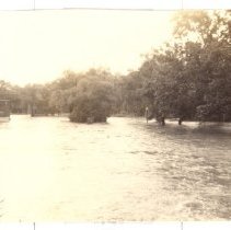
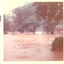
P-0066.01 - DISASTER / FLOOD 1972 & 1936
DISASTER - FLOODS High water levels from Hurricane Agnes in June 1972 1 - Power house; 6 - Spring Creek golf course;
Record Type: Photos Search
-
P-0066.03 - DISASTER / FLOOD 1972 & 1936
DISASTER - FLOODS High water levels from Hurricane Agnes in June 1972 25 - West Main Street, Sand Beach looking west; 26 - Car partially submerged in Sand Beach; 27 - Bank of Swatara Creek north of Swatara Creek at area of old covered bridge, looking at MHS Unit #5; 28 - North side of Swatara Creek at bridge on Sand Beach Road, MHS student home on south side of Swatara Creek; 29 - View...
Record Type: Photos Search
-
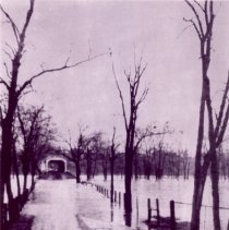
P-0066.05 - DISASTER / FLOOD 1972 & 1936
DISASTER - FLOODS High water levels from 1936 flood. 45 -1936 flood when Sandbeach covered bridge was still standing;
Record Type: Photos Search
-
P-0066.06 - DISASTER / FLOOD 1972 & 1936
DISASTER - FLOODS 46,47,48,49 - Hershey Park - High water around rides in hollow area of the park during the flood of 1972 - note one photo shows only the light fixture from the top of the Whip;
Record Type: Photos Search
-
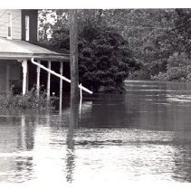
P-0066.07 - DISASTER / FLOOD 1972 & 1936
DISASTER - FLOODS High water levels from Hurricane Agnes in June 1972 50,51,52 - 1972 Flood - Looking west at Trinidad and Park Ave - note the Monorail from the park over Park Avenue - Water had receded several feet at this time; 53 - Standing in front of 325 Park Ave looking south toward Bowling-Alley Hill; 54 - View from entrance to silos; 55 - Looking at silos from porch at 139 Trinidad Ave - wate...
Record Type: Photos Search
-
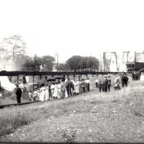
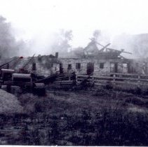
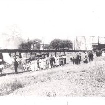
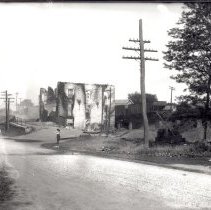
P-0090.03 - BUSINESS / CURRY'S FEED MILL
CURRY'S FEED MILL 1- Crowd of people viewing the complete devastation of the Curry Feed Mill fire of May 30, 1914; 2 - A view of the destructive fire from the railroad side of the building - note the house that can be seen through the smoky haze - that is the Swatara Hotel on the north side of the railroad near the underpass of Chocolate Avenue; 10 - Fire Truck being loaded with water from a railroad tanker car at Curry'...
Record Type: Photos Search
-
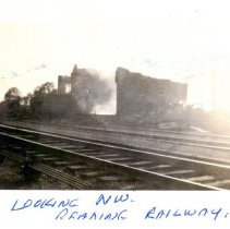
P-0090.04 - BUSINESS / CURRY'S FEED MILL
CURRY'S FEED MILL The fire occurred on May 30, 1914 11,12 - Looking northwest at the smoldering fire at Curry's Feed Mill from a point just west of Reading Railway overpass on old West Chocolate Avenue; 13 - Looking southwest while standing on the old Chocolate Avenue side of the mill; 14 - Looking east - with the road on one side and the railroad on the other; #15 - Looking south from ...
Record Type: Photos Search
-
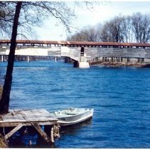
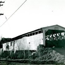
P-0179.02 - BRIDGE / SANDBEACH
SAND BEACH BRIDGE The Sandbeach Covered Bridge was restored in 1964 and burned down in 1966; 10 - A beautiful color photograph of the bridge with dingy tied to a dock - it appears the photo was taken during the restoration - note the varied colors of the side boards;
Record Type: Photos Search
-
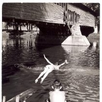
P-0179.03 - BRIDGE / SANDBEACH
SAND BEACH BRIDGE The Sandbeach Bridge, was restored in 1964 and burned down in 1966; 7 - Children diving off the bank near the bridge; *
Record Type: Photos Search
-
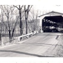
P-0179.07 - BRIDGE / SANDBEACH
SAND BEACH BRIDGE Sandbeach Covered Bridge was restored in 1964 and burned down in 1966. 13 - Bridge entrance; 14 - View of Swatara Creek from the bridge;
Record Type: Photos Search
-
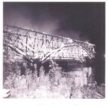
P-0179.09 - BRIDGE / SANDBEACH
SAND BEACH BRIDGE Sandbeach Covered Bridge, restored in 1964, burned down in 1966 17 - Sand Beach Bridge Fire - September 3, 1966;
Record Type: Photos Search
-
P-0179.12 - BRIDGE / SANDBEACH
SAND BEACH BRIDGE 19 - Sandbeach Covered Bridge, before restoration in 1964, burned down in 1966.
Record Type: Photos Search
-
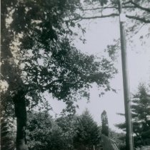
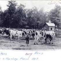
P-0233.04 - FARM / OWNED BY M. S. HERSHEY
FARM OWNED BY M.S. HERSHEY 2 - Father "Pappy Hess" and his two children, Levi A and Harry Hess herding cattle on a Hershey farm in 1907; 3 - Men on the same Hershey farm, managed by Levi Hess, surrounding a traction engine; 4 - The same traction engine that later fell through a wooden bridge into Manada Creek; *
Record Type: Photos Search
-
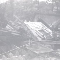
P-0703 - DISASTER / FIRE - PLANING MILL
PLANING MILL FIRE 1,2,3,4,5,6,7,8,9,10 - Various views of the remains of the Planing Mill after a major fire destroyed the structure - the Planing Mill was on West Chocolate Avenue and Mill Road near the railroad underpass.
Record Type: Photos Search
-
P-0871 - DISASTER / FIRE - CURRY'S MILL
DISASTER / CURRY'S MILL 1 - Crowd of people viewing the complete devastation of the Curry Feed Mill fire of May 30, 1914 - Looking east, with the road on the left and the railroad on the right;
Record Type: Photos Search
-
P-0871.01 - DISASTER / FIRE - CURRY'S MILL
DISASTER / CURRY'S MILL 2 - Crowd of people viewing the burnt out Mill from south-west of the Mill; 3 - A view of the destructive fire from the railroad side of the building - note the house that can be seen through the smoky haze is the Swatara Hotel on the north side of the railroad near the underpass of Chocolate Avenue;
Record Type: Photos Search